


3.5 km | 4.6 km-effort
![Trail On foot Poříčí nad Sázavou - [M] Týnec n. S. - Poříčí n. S. - Photo](https://media.geolcdn.com/t/1900/400/a945f703-f7b0-46ec-baf8-bf941e8d859d.jpeg&format=pjpeg&maxdim=2)

Tous les sentiers balisés d’Europe GUIDE+


FREE GPS app for hiking
 SityTrail
IGN / Geographical institutes
SityTrail World
The world is yours!
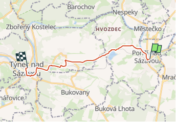
Trail On foot of 8.3 km to be discovered at Central Bohemia, Unknown, Poříčí nad Sázavou. This trail is proposed by SityTrail - itinéraires balisés pédestres.
Trail created by cz:KČT.
![Trail On foot Poříčí nad Sázavou - [M] Týnec n. S. - Poříčí n. S. - Photo 1](https://media.geolcdn.com/t/2048/auto/a6005933-f83f-4f85-9007-f662d38233ab.jpeg&format=jpg&maxdim=0 "Trail On foot Poříčí nad Sázavou - [M] Týnec n. S. - Poříčí n. S. - Photo 1")
![Trail On foot Poříčí nad Sázavou - [M] Týnec n. S. - Poříčí n. S. - Photo 2](https://media.geolcdn.com/t/2048/auto/2322d19e-23e8-4ff2-ae0e-10c749dc1a05.jpeg&format=jpg&maxdim=0 "Trail On foot Poříčí nad Sázavou - [M] Týnec n. S. - Poříčí n. S. - Photo 2")
![Trail On foot Poříčí nad Sázavou - [M] Týnec n. S. - Poříčí n. S. - Photo 3](https://media.geolcdn.com/t/2048/auto/967ab6c7-5306-4e71-8e31-79c17ecd11fc.jpeg&format=jpg&maxdim=0 "Trail On foot Poříčí nad Sázavou - [M] Týnec n. S. - Poříčí n. S. - Photo 3")
![Trail On foot Poříčí nad Sázavou - [M] Týnec n. S. - Poříčí n. S. - Photo 4](https://media.geolcdn.com/t/2048/auto/777bbd61-a36e-4137-862f-1da817568004.jpeg&format=jpg&maxdim=0 "Trail On foot Poříčí nad Sázavou - [M] Týnec n. S. - Poříčí n. S. - Photo 4")
![Trail On foot Poříčí nad Sázavou - [M] Týnec n. S. - Poříčí n. S. - Photo 5](https://media.geolcdn.com/t/2048/auto/1d2cd467-df36-4c57-a5d7-ed7f27fbbdb0.jpeg&format=jpg&maxdim=0 "Trail On foot Poříčí nad Sázavou - [M] Týnec n. S. - Poříčí n. S. - Photo 5")
![Trail On foot Poříčí nad Sázavou - [M] Týnec n. S. - Poříčí n. S. - Photo 6](https://media.geolcdn.com/t/2048/auto/7c0bb2dd-a7c8-4cc1-a852-afbb61aa4538.jpeg&format=jpg&maxdim=0 "Trail On foot Poříčí nad Sázavou - [M] Týnec n. S. - Poříčí n. S. - Photo 6")
![Trail On foot Poříčí nad Sázavou - [M] Týnec n. S. - Poříčí n. S. - Photo 7](https://media.geolcdn.com/t/2048/auto/40a34d9b-043c-493a-a61c-b664161fafa7.jpeg&format=jpg&maxdim=0 "Trail On foot Poříčí nad Sázavou - [M] Týnec n. S. - Poříčí n. S. - Photo 7")
![Trail On foot Poříčí nad Sázavou - [M] Týnec n. S. - Poříčí n. S. - Photo 8](https://media.geolcdn.com/t/2048/auto/91721de2-1858-45e0-bbe8-b3a6e9b6e8db.jpeg&format=jpg&maxdim=0 "Trail On foot Poříčí nad Sázavou - [M] Týnec n. S. - Poříčí n. S. - Photo 8")
![Trail On foot Poříčí nad Sázavou - [M] Týnec n. S. - Poříčí n. S. - Photo 9](https://media.geolcdn.com/t/2048/auto/584cb827-a675-44b6-88cc-d1d4e5a96346.jpeg&format=jpg&maxdim=0 "Trail On foot Poříčí nad Sázavou - [M] Týnec n. S. - Poříčí n. S. - Photo 9")
![Trail On foot Poříčí nad Sázavou - [M] Týnec n. S. - Poříčí n. S. - Photo 10](https://media.geolcdn.com/t/2048/auto/a945f703-f7b0-46ec-baf8-bf941e8d859d.jpeg&format=jpg&maxdim=0 "Trail On foot Poříčí nad Sázavou - [M] Týnec n. S. - Poříčí n. S. - Photo 10")
![Trail On foot Pyšely - [M] Pyšely žst - Pyšely Loreta - Photo](https://media.geolcdn.com/t/375/260/67976ba2-0958-47e5-97b5-e8131ae8a420.jpeg&format=jpg&maxdim=2)
On foot
![Trail On foot Poříčí nad Sázavou - [Č] Poříčí n. S. - Benešov - Photo](https://media.geolcdn.com/t/375/260/fd2d8f48-a91f-479c-bf66-87184c69822c.jpeg&format=jpg&maxdim=2)
On foot
![Trail On foot Čerčany - [Z] Čerčany - Poříčí n. S. - Photo](https://media.geolcdn.com/t/375/260/ede0169c-97fd-4e44-b5a1-bce727974295.jpeg&format=jpg&maxdim=2)
On foot